Wednesday, 13 June 2012

French ridge

So attempting it when wet and icy/snowy will be fine
The view from Shovel flats towards Wanaka
The view down the valley  in the morning
The walk was from Raspberry Creek Car park to Aspiring Hut, where we spent the night and then up to French ridge.

 The first days walk to Aspiring hut was quite gentle although I will admit my feet were killing me when we got there as I was wearing big winter boots on a dirt track. Aspiring hut was massive and the fire was teeny compared to the whole room especially as there was only two of us in there.

The sun peeping through the trees
First hint of snow on the track to French ridge hut
 The second day took us from Mt Aspiring hut to French ridge a height gain of 900m seemed easy enough. According to the sign it should take us 3 hours. The track was a little icy and we had to start using ice axes to clear ice and get up scrambles after about 400m (at 900m height above sea level). The track was a little difficult and then once out of the tree line it was knee deep snow. It took us a respectable 5 hours.
Just above the tree line after some exciting scrambling.

Mount Aspiring so close yet so far

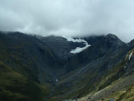
The view into Gloomy gully with our shadows.

The view while washing up was good
 When we got the the hut after probably the longest 1.2km ever. it was lovely but cold there are no wood burning stoves in the higher altitude huts (except for the wardens cabin which are left locked) so it can get a bit cold in there. There is clean water and the toilet is on stilts about 100m from the main hut. When we got in I was really tired and couldn't work out why I couldn't get my shoe laces undone. My boot were frozen. The snow on the picture had frozen in place while we were walking and I couldn't shift it. The next day I also had a great time putting them on.

However the no heating in the hut did nothing for my frozen boots.
The hut boasts an array of activities including this hopscotch board on the floor


Nick in front of Mt French trust me it is there behind the clouds.
Yay
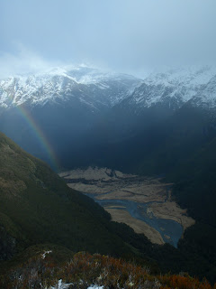
Rainbow on the way down
Day three started later than planned as we waited for the weather to calm down a little and we walked up French ridge for as far as we could see a view. Then the clouds came in and we walked down to a beautiful day in the valley floor

Thursday, 7 June 2012

Mt Iron at sunset

The view of the moon a short way from the summit of Mt Iron
The view towards Lake Hawea
Sun setting over Mt Aspiring


The beautiful planes towards Luggate


Mt Aspiring and Lake Wanaka

Lake Hawea but a bit darker


Wanaka, Lake Wanaka and Mt Aspiring

Wednesday, 30 May 2012

Copland Track


The Copland track is a one day tramping track on the west coast. I got there by bus on the main west coast highway, the picture on the left made me laugh as I can't imagine anyone in the UK moving cattle in a pick up truck down a main road.


Walking up through the valley in a proper rainforest
Getting darker
The walk started at 3pm and took 5 hours so some of it was in the dark. There were only a few streams to cross on the way there and a few bridges. by the time I got to Architect bridge it was pitch dark. It is made of fence posts wire and fence cabling. The light reflected off the metal so I couldn't see anything below and when I tried to look over the side the bridge swung quite a lot. Much nicer to cross in the daylight.
Terrifying bridge


Possum eyes glowing red in the light.
Mmmmm nice warm water

 The walk was quiet except for the possums and the morporks (a type of owl). The possums were really cute right up until one woke me up the next night. I went in the beautiful hot pools and soon scary bridges were forgotten. I did get out of the hot pools long enough to take a few scenery photos.
Copland River
More Copland river
Me in the hot pool relaxing

Water bubbling up from the ground
 The water in the hot pools have taken 200 years to warm up and reaches the surface at 55 degrees C however once it has run over the rocks it cools a little. Depending on where you sit in the pool. When it rains heavily the water can cool to 37 degrees.
Bridge over the Copland river


Thursday, 26 April 2012

The Skyline

 We started on the Cardrona road on the Spotts creek track and moved up through the valleys onto the ridgeline.


The track is 22km long with a height gain of 1200m (ish) The day was beautiful and dry. Although it was still cold at the top. This took us 8 hours and 30 minutes which we were impressed by especially as it was dark for the last 20 minutes or so.
Walking up through the valleys to the ridgeline
 The first peak to get to was Mount Alpha which we approached via spotts creek. The bush is sparse but unfortunately on the lower end of the walk the cows were not and there was a lot of mud and other things on the ground as evidence. The walk up to mount Alpha is relatively gentle and pleasant as you are walking up a mountain (hill in these parts). Once you are up Mount Alpha to get to Roys Peak is a little more entertaining with steep drop offs to the side and narrow paths with scree (not a walk for anyone who doesn't at least appreciate heights. It is not recommended to stand anywhere on this path and tell your friend to look down at the beautiful drop below them for some reason this was not appreciated. The final point Roys Peak is a point where people go for day walks or run to the top of for a bit of light exercise (quite a lot of crazy people in Wanaka) as it is only 1200m height gain.
Although it was warm there was still ice on the path in places

Cardrona range


Yey first summit completed now for the second
The final stretch of ridgeline was spectacular and fun with Roys Peak in the background

I can see my house from here


Sunday, 18 March 2012

Gillespie pass

Lovely young river valley
 Day One Young river valley to Young hut

Beautiful day and a great day to cross a river (bridges are for wimps) and go to the young hut. The day was lovely and the views spectacular.
Nice native forest
Ok this bridge is not for wimps
The sign on the bridge
Beautiful river

More beautiful river valleys
Day two Young Hut to Siberia Hut

Day one was the warm up day two is the harder day. But with the amazing views of the NZ mountains. Unfortunately there is also the NZ weather and it hit with 50Km winds on the way up.

young valley the Gillespie pass

The view on the other side


The wonderful view of mount Awful

Pretty glacier (this will appear again)
The walk wasn't sunny but apart from the wind it was lovely. But I was quite pleased after 7 hours (and 900m ascent) to reach Siberia hut.


Siberia hut situated in the beautiful Siberia Valley

The view from Siberia Hut


Day three didn't go to plan

Got up to find that the weather forecast was too accurate the day before.
 
The view at 8:15 this morning
The weather just got worse this is the view at 9:15


The trip got cut a little short and the helicopter ride didn't happen however the alternative was quite good fun.


Day three the alternative plan (the jet boat option)

 Really fast boat that does flat spins what is not to like. Well maybe rain hitting you in the face wasn't much fun.
Not so much fun having rain hit you in the face while going really fast