Saturday, 17 November 2012

Trip to Haast beach

Gates of Haast
 The trip started in the rain and the rivers were stunning the Gates of Haast is a bridge over the river Haast and was very full. The Haast mountain pass is the lowest route over the Southern Alps.
Jackson Bay looking so sunny

A proper rainforest has rain

A short walk from Jackson Bay is a world away

Pioneer cemetery

Tuesday, 2 October 2012

day out in Queenstown area

Photo taken from the base of the Crown range road
I thought I would start this blog post off with a photo of the mountains above Queenstown and the spectacular clouds. Unfortunately I'm injured for a short time and so my photos are going to be less adventurous and more sedate.

This is the sign at the entrance to the road I've been warned

We drove along one of New Zealands most dangerous roads luckily for me and the other people in the car I wasn't driving. The road is a single track road near coronet peak and is an actual NZ road with road markers on the side of the road. There is a large land slide on the road and the council are working to clear it. We went to check it out.
Yes that is the road on the side of the cliff
The landslide covering the road is left of the digger

This river is used for rafting and jet boat rides

Big digger
The next activity on the agenda was gold panning and I'm afraid I was having too much fun to take photos and it was raining. But I did get a photo of the gold we found.
Gold!

Sunday, 30 September 2012

My busy week

This lovely sign is on a few tracks in NZ.
 My Busy week started as all good weeks do with a bad weather forecast. The weather for the first active day of the week was for rain and strong winds. So I thought I would climb a mountain. Turns out the weather forecast was half right. I couldn't get to the top due to the strong winds, but at least the rain held off.  The Isthmus track is a short steep track above Lake Hawea. If you make it to the top on a clear day you can see both Lake Hawea and Lake Wanaka.
Lake Hawea looking beautiful from Isthmus track

So close but so far. The tussock grass shows how windy it was
The Second day of excitement was at Treble Cone and the rain promised for the previous day appeared in the evening and the day was absolutely gorgeous.
The view from the top of the six chairlift at TC

View of Lake Wanaka from TC so amazing.

OOh fresh powder new slopes I think so
Marion showing everyone how its done

Day at Cardrona was another lovely day Marion and Mike kept me company, and I watched them pulling some awesome moves.

Woo hoo new slopes to try

Another top of chairlift photo, this time from Captains


Wednesday, 27 June 2012

Single cone

Frozen Lake
Views across the mountains inland towards Alexandria
This is the first day trip I have posted on here so it's slightly new. The trip up to single cone starts off at the Remarkables ski field near Queenstown. The trip goes up the fields then along the side of a frozen lake (we went over it as it was flatter). Then the only way was up.


More views towards Queenstown and the crown range
Writing in the snow with an ice axe is harder than it looks

Finally made it to the top of single cone and you can just see Queenstown in the right hand corner

The sunset as we were walking down

Wednesday, 13 June 2012

French ridge

So attempting it when wet and icy/snowy will be fine
The view from Shovel flats towards Wanaka
The view down the valley  in the morning
The walk was from Raspberry Creek Car park to Aspiring Hut, where we spent the night and then up to French ridge.

 The first days walk to Aspiring hut was quite gentle although I will admit my feet were killing me when we got there as I was wearing big winter boots on a dirt track. Aspiring hut was massive and the fire was teeny compared to the whole room especially as there was only two of us in there.

The sun peeping through the trees
First hint of snow on the track to French ridge hut
 The second day took us from Mt Aspiring hut to French ridge a height gain of 900m seemed easy enough. According to the sign it should take us 3 hours. The track was a little icy and we had to start using ice axes to clear ice and get up scrambles after about 400m (at 900m height above sea level). The track was a little difficult and then once out of the tree line it was knee deep snow. It took us a respectable 5 hours.
Just above the tree line after some exciting scrambling.

Mount Aspiring so close yet so far

The view into Gloomy gully with our shadows.

The view while washing up was good
 When we got the the hut after probably the longest 1.2km ever. it was lovely but cold there are no wood burning stoves in the higher altitude huts (except for the wardens cabin which are left locked) so it can get a bit cold in there. There is clean water and the toilet is on stilts about 100m from the main hut. When we got in I was really tired and couldn't work out why I couldn't get my shoe laces undone. My boot were frozen. The snow on the picture had frozen in place while we were walking and I couldn't shift it. The next day I also had a great time putting them on.

However the no heating in the hut did nothing for my frozen boots.
The hut boasts an array of activities including this hopscotch board on the floor


Nick in front of Mt French trust me it is there behind the clouds.
Yay
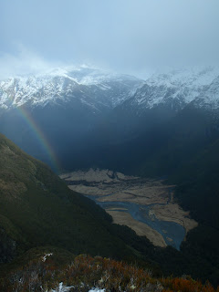
Rainbow on the way down
Day three started later than planned as we waited for the weather to calm down a little and we walked up French ridge for as far as we could see a view. Then the clouds came in and we walked down to a beautiful day in the valley floor

Thursday, 7 June 2012

Mt Iron at sunset

The view of the moon a short way from the summit of Mt Iron
The view towards Lake Hawea
Sun setting over Mt Aspiring


The beautiful planes towards Luggate


Mt Aspiring and Lake Wanaka

Lake Hawea but a bit darker


Wanaka, Lake Wanaka and Mt Aspiring

Wednesday, 30 May 2012

Copland Track


The Copland track is a one day tramping track on the west coast. I got there by bus on the main west coast highway, the picture on the left made me laugh as I can't imagine anyone in the UK moving cattle in a pick up truck down a main road.


Walking up through the valley in a proper rainforest
Getting darker
The walk started at 3pm and took 5 hours so some of it was in the dark. There were only a few streams to cross on the way there and a few bridges. by the time I got to Architect bridge it was pitch dark. It is made of fence posts wire and fence cabling. The light reflected off the metal so I couldn't see anything below and when I tried to look over the side the bridge swung quite a lot. Much nicer to cross in the daylight.
Terrifying bridge


Possum eyes glowing red in the light.
Mmmmm nice warm water

 The walk was quiet except for the possums and the morporks (a type of owl). The possums were really cute right up until one woke me up the next night. I went in the beautiful hot pools and soon scary bridges were forgotten. I did get out of the hot pools long enough to take a few scenery photos.
Copland River
More Copland river
Me in the hot pool relaxing

Water bubbling up from the ground
 The water in the hot pools have taken 200 years to warm up and reaches the surface at 55 degrees C however once it has run over the rocks it cools a little. Depending on where you sit in the pool. When it rains heavily the water can cool to 37 degrees.
Bridge over the Copland river