Monday 20 February 2012

The Glaciers

Franz Josef glacier

The Franz Josef Glacier and the Fox glacier (yes it is the same as the mint) are the lowest glaciers in New Zealand as the base of them are below 300m below sea level. They are other glaciers this low but they are in Patagonia. The Franz Josef Glacier is very steep and the Fox glacier is not as steep. 
very cold and wet on the glacier
Halfway up the glacier


The cave in the glacier
Trying to smile while cold wet and windy didn't really work.
finally the fog cleared on the way down
After Franz the smaller and slightly more lovely town of Fox. We decide to go up Fox mountain the two lovely girls I was with were not impressed with the walk however we got there. It was incredibly foggy at the top so unfortunately we didn't get the views of the glacier but it was still an interesting walk.
view of the mountains
Always a good sign to see
 The glacier at fox was brilliantly blue and the valley show definite signs of a glacial valley. The straight sided cliffs were spectacular and massive.
The terminal face of Fox glacier


 The famous "mirror lake" only works when there is no wind unfortunately this was not one of those times. It was still a gorgeous place to go to.


Greymouth and around

Toby and Stuart walking on a brand new bridge
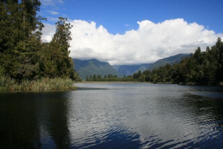
 Visiting Greymouth was lovely although I have to say I didn't see much of Greymouth probably a good thing.

Punakaiki (the pancake rocks) were amazing and we saw Hector dolphins while we were there. Linda is amazing at spotting dolphins I am rubbish. We went for a walk before the rocks and went into one valley up and round into another. There were several new bridges as a few hikers got stuck in the valley when the water came up in the rivers and they couldn't cross the fords any more.
These rocks on the right are all along the walk
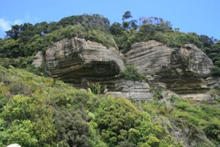
Sedimentary rocks
but mainly hidden by trees they are a wonderful
example of sedimentary rocks and they have beenpushed up from beneath the sea by earthquake action.
 Punakaiki is very famous for these structures, limestone (a sedimentary rock) was pushed up somehow (no one knows how, I'm going for the old standby magic) and the wave action has weathered it into these wonderful shapes. There is a blow hole which can spout water out onto the footpath but it only works at high tide and with quite a bit of swell. It was too nice a day for it to work.
The next day we went to an abandoned gold mine town it had been quite a large town but it was abandoned when the gold ran out. At the top of the hill there were loads of structures and holes from the mine. It was very eerie, especially when we saw the abandoned swimming pool. weirdly enough they had all sorts of stuff there like a butchers, hospital, church, school and a whippet track. I mean what self respecting town doesn't have a whippet track. The bowling green was still there and the rugby pitch was still being used.

Thursday 9 February 2012

Arthurs Pass


 Arthurs Pass is 750m above sea level and runs across the Southern Alps.

The Devils Punchbowl has a 131m waterfall and a lovely viewing platform for visitors. There is also a lovely little path and some big boulders to scramble over in the summer. The last bit is not signposted but the most fun.


The Avalanche Track
This track climbs 1300m up to Avalanche peak although the avalanche risk on this track can be very high it was very low when I walked up there mainly due to the fact that there was no snow
Starts off steep but in the shade
Little grasshoppers all the way along the track
 The track started off very steep and in the shade which was welcome on such a hot day. There were loads of birds in the lower sections and grasshoppers in the upper sections of the walk. I felt so sorry for the people who didn't start so early in the morning.


Still in the tree line
Just coming out of the tree line

The glacier


It was very warm at the top but the Kea didn't seem to mind it watched me and followed me around at the top of the mountain. They are extremely cheeky and are known for nicking food and damaging cars. There are loads of signs warning people about leaving food around or feeding the Kea as that can cause them to rely on humans and lose their ability to scavenge for food. 
Kea fluffing its wings and showing off for the camera


Kea following me and taking flight

Kea looking at the view

Kaikoura

 
Fur Seals are all around the Kaikoura coast but at the end of the Peninsular walk they are very close to the shore and know that they are in no danger from the humans. There are big signs saying how close your allowed to be to them as their bite can be quite bad. There were quite a few people really close but luckily for them the seals hadn't read the signs.


 This was a really plant and a very tame seabird but I havn't found a library open yet to check out what they are yet.

 The coast around New Zealand is apparently very special as the depth of water is very deep only 4 nautical miles from the land. This means the whales are present really close to the shore. The whales we saw were sperm whales and they have a large oil/fat storage area in their skull which they use to regulate their buoyancy. To dive they suck in cold water in their nose and the fat solidifies, when they want to surface they eject the water and warm up the fat by pumping warm blood into vessels around the fat. This liquefies the fat and they start to float.

 The blow hole is at the front of their nose and in this picture you can see how long the whale is.
The boat is the same length as the whale
Diving


moving away from the boat.

Really close to the boat

Going...

Going...

Going...

Gone

Wellington continued

Football about to start at the Phoenix
Ok this is in the wrong order but missed the photos before. I went to my first ever football match and saw Wellington Phoenix beat Melbourne Hearts by a long way. The first goal was scored in the first 3 minutes. We also went to the zoo and saw sea birds being fed and the sleepy red panda in the trees.
 
Red panda at the zoo

Sunday 5 February 2012

The Queen Charlotte track


The Queen Charlotte track is a footpath along the Marlborough sounds it is an area where there is a range of bush and great views. So many people do this track that you can get your bags taken by water taxi to the accommodation so you don't have to carry your stuff all the way. Lazy I know but brilliant. The information says the track should take 4 to 5 days however the tourist office says 3 is fine so we did it in 3 days.

Day 1
Maori carving to Cook's monument

 Ship Cove to Noeline's Homestay at Camp bay 27 Km

Ship cove is where James Cook first landed in the Queen Charlotte sound with the Endeavour. They built the monument so tourists wouldn't get confused 100 years ago. Just up the bay from here is cannibal cove where some of his crew met the Maoris and that was it for them.
 After the first hill this is what we saw
You can see some of the oldest forest in the area in this photo.

Tree fern with a few epihytes

Ralph chills out on the bridge
Far away from anywhere.
The view from Noeline's balcony
The view point was worth the walk up there
 Day 2 Noeline's to Portage bay only 25Km today except we did a little extra to get to the viewpoint.


Ralph shows the way. The viewpoint shows we are closer to Antarctica than London
Natural woodland


The larvae of the cicada

the cicada which only lives a few days


Day 3 Only 20Km Portage bay to where we get picked up at 3.30.

We still had time to take photo's of the Wika
Claudia takes a break
Massive tree with loads and loads of epiphytes
 

We Made it Sarah, Ralph and Claudia pose for the last Km marker its's a great feeling once you've done 70Km to walk the last Km and know you've got plenty of time not to miss the ride home.

www.qctrack.co.nz